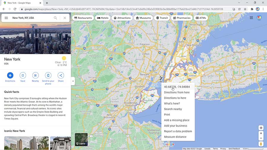
Do you need to find the exact coordinates of a location on Google Maps?
Follow this quick tutorial to learn how to locate the coordinates and copy them to your clipboard.
First, let’s go over the history of Google Maps and some of the application features.
Then, you can read the step-by-step guidelines and view the YouTube tutorial to further clarify what to do.
About Google Maps
Google originally launched Google Maps on February 8, 2005. The app has satellite imagery, street maps, panoramic street views, traffic updates, and direction features. Most people use the app for navigating through a city and finding public transportation routes. Plus, you can search for a location by entering the location name — or by entering the decimal degrees relating to the latitude and longitude.

Tutorial: How to Get Google Maps Coordinates
To begin, open your Chrome browser or preferred web browser. Now, follow the steps below to find the map coordinates in Google Maps.
- Go to Google Maps.
- Search for the location by entering the city’s name. (In this example, we will use New York to demonstrate.)
- Then, right click on the location with your mouse.
- The coordinates will appear at the top of the pop-up menu.
- Simply click the coordinates to copy them to your clipboard.
- Finally, you can copy the coordinates to wherever you like.
Would you like more tips on finding map coordinates?
Watch the YouTube tutorial below to learn more.
Watch the Video Tutorial on YouTube
Feedback: Questions and Comments on YouTube
Do you have any questions or comments about how to find map coordinates on Google Maps?
Please leave your feedback on YouTube after watching the video tutorial on How to Get Google Maps Coordinates.